Showing posts with label Portwood. Show all posts

Thursday, 20 August 2015

Upholsterers of distinction


Upholsterers of distinction claims the nameplate on the former premises of the Stockport Restoration Co. on Avenue Street.


The building on the tautologically named Avenue Street off Great Portwood Street probably looked quite stylish in its day.


Buddleia is a plant that will grow almost anywhere and loves to attach itself to derelict buildings such as this.

A contribution to signs, signs and Floral Fridays.

Saturday, 14 June 2014

Richard Street, Portwood


In the background is the M60 motorway and beyond that are the tower blocks on Lancashire Hill.

A contribution to The Weekend in Black and White.

Thursday, 13 February 2014

Footpath signs below the motorway


Short and long distance footpaths, including the Fred Perry Way and the Trans Pennine Way, come together in the Knightsbridge area where the river Goyt meets the river Tame to create the river Mersey.

Traffic on the M60 motorway thunders by oblivious of the rivers and walkers below.

A contribution to signs, signs.

Friday, 31 January 2014

Meadow Mill from Penny Lane Fields


Meadow Mill was built in the late 1870s for T & J Leigh, cotton and wool spinning. It had 120,000 spindles in 1914. It is grade II listed.

The little building in the foreground is the Grimesbottom Stormwater Overflow.

A contribution to Skywatch Friday.

Thursday, 30 January 2014

Grimesbottom Stormwater Overflow


This innocent looking little building carries several warning notices:

Caution Hazardous Areas
Caution Deep water
Warning Machinery may be in operation at any time
This site contains confined space Check register for confined spaces
No unauthorised persons allowed beyond this point
No smoking
Approved personal protective equipment must be worn at all times
Keep Clear 24 hour access required

So that's you lot told.

A contribution to signs, signs.

Sunday, 26 January 2014

Penny Lane Fields


Lying between Portwood and Lancashire Hill, Penny Lane Fields is a 10 hectare area which is going to be made part of the Reddish Vale Country Park in compensation for the loss to the park of 1.3 hectares earmarked in Brinnington for new housing and a leisure centre.

A contribution to Shadow Shot Sunday.

Wednesday, 23 October 2013

O is for the Old King


The Old King public house was built in c.1828, and remodelled in 1973. The building was constructed of red brick laid in Flemish bond, to the original phase, the 1970s phase was built of brown stretcher bond brick. The 2-storey, 4-bay frontage retained early 19th century fabric to the right hand bay only, the rest was re-fronted and all windows were 20th century. To the rear was a late 19th century single-storey function room, and a mono-pitch 19th century outbuilding, possibly a brew house or store.


Standing on the corner of Great Portwood Street and Lancaster Street it was a listed building pictured here "for sale" in 2008.


In 2011 it was still waiting for a buyer.


In April 2012 I happened to walk into Lancaster Street and found this scene.


Despite being listed it was demolished to make way for a branch of Nando's.


A contribution to ABC Wednesday and signs, signs.

Sunday, 25 August 2013

The end of the river Tame


This is the view downstream from the last footbridge over the river Tame. It is crossed by a pipework bridge and then flows under the M60 motorway to join the river Goyt and form the river Mersey.


This is the view looking back from under the motorway. The footpath alongside is part of the Trans Pennine Trail.


Before the motorway was built the Cheshire Lines Committee (CLC) railway line through Stockport (Tiviot Dale) crossed the river Tame between these two crossing points. Now only the buttresses remain. It has been reported that these precarious perches have been used as sleeping quarters by homeless people.

A contribution to Sunday Bridges at San Francisco Bay Daily Photo.

Monday, 19 August 2013

A marriage of weeds


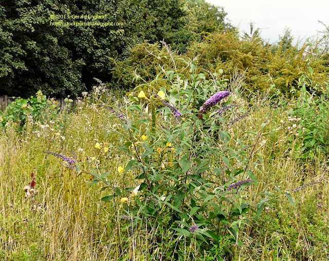
In the wasteland between Brewery Street and the M60 motorway at Portwood the weeds have taken over. Evening primroses and buddleia are entwined together in an unholy marriage.


For a closer view of a bee on the buddleia see my photoblog sithenah.

A contribution to Monday Mellow Yellows.

Saturday, 17 August 2013

The Last Bridge Over The Goyt


Howard Street bridge is the last bridge to cross the river Goyt before it flows over a weir, meets the river Tame and forms the river Mersey.

A contribution to Weekend Reflections and Sunday Bridges at San Francisco Bay Daily Photo.

Friday, 2 August 2013

Vernon Mill


Vernon Mill at Portwood, a listed building is a typical mill of the turn of the twentieth century, it was built before 1917 of red brick and terracotta with a flat roof and demonstrates the changes in architectural form as improved technology allowed larger and better-lit mills to be built.

EXTERIOR: 4 storeys, approx 15x8 bays, 3-bay projection left, Italianate tower in angle with lettered parapet:: 'VERNON', angle pilasters, tiled roof with wrought iron cresting and flag pole; tower at north west corner. Large paired and triple windows with metal frames, pilasters between, moulded sill bands, modillion eaves and parapet.

INTERIOR: Steel frame with cast iron columns, concrete floors; ground floor lateral segmental brick arches supported by tall cast-iron columns, flagstone floor.

West façade has added projecting covered loading bay centre, rope race tower right and lower attached engine house at SW corner with windows (reduced) in round-arched recesses and fine tall window (lower part now workshop entrance) on south side ; arches have imposts and keystones, low segmental gable pediment. Single and two storey preparation and loading warehouse range on the South side of the main block has inserted ground floor entrances, segmental arched windows, upper floor loading door, roof lights, water tower. At the entrance to the mill, the NW corner, the single storey office /reception block has stone detailing, round arched windows of 2 and 3-lights, corner pilasters carried up above parapet height, no finials. Subsidiary features: the main mill entrance detailing includes office railings with bulbous finials on low brick and stone boundary wall; stone gate pier approx. 2.5m high with square base, moulded capstone with domed finial, attached gate with close set rails and curved brace.

Originally a cotton spinning mill, it now houses various industrial units.

A contribution to Skywatch Friday.

Sunday, 28 July 2013

River Goyt under St Mary's Way Bridge


As the river Goyt passes under St Mary's Way bridge it divides around a grassy island.


This is the view looking downstream from the bridge.


And another from a slightly different angle.


And here's one I took earlier - in March 2009.

A contribution to Sunday Bridges at San Francisco Bay Daily Photo.

Thursday, 25 July 2013

Sign of a Quiet Pub


The sign by the doorway to The Railway Inn on Great Portwood Street describes it as a "Quiet Pub" - No Juke Box; No Pool Table.

It is one of three real ale pubs supplied by the Rossendale Brewery.

Before you ask; I don't know what it is like inside; I'm teetotal; I photograph pubs but don't frequent them.

A contribution to signs, signs.

Saturday, 6 July 2013

River Goyt from Park Bridge


The River Goyt as viewed from Park Bridge on Great Portwood Street.

The Goyt rises on the moors of Axe Edge, near the Cat and Fiddle Inn. It runs from the Errwood and Fernilee reservoirs, north of Buxton to Stockport where just around the next bend it joins the River Tame to form the Mersey.

A contribution to Weekend Reflections and Scenic Weekends.


Wednesday, 5 June 2013

U is for Underpass


A look through one of the underpasses at Portwood roundabout. Several footpath and cycleways cross under the roads. Between two of them is a "Help point". I'm not sure whether its presence is re-assuring or actually alarming. I certainly wouldn't venture there after dark.


A contribution to ABC Wednesday.

Thursday, 23 May 2013

Sign approaching Portwood roundabout


Sign on Great Portwood Street approaching Portwood roundabout. Note how the sign appears to be made up of three sections that don't quite align with each other.

The Portwood roundabout is at junction 27 of the M60 motorway.
There is a westbound entry slip road and an eastbound exit slip road.
The other roads leading on to the roundabout are Tiviot Way, the A626 from Lancashire Hill;
Crookilley Way, the new A560 built at the same time as the M60 from the westbound exit of the motorway;
Carrington Road, the original A560 from Bredbury, now the B6104;
St Mary's Way, the A626 from Marple;
Great Portwood Street, the A560 out of Stockport.
A busway allows Eastbound buses to cross the roundabout rather than go round it.
In 2012 an additional road off the roundabout was constructed leading into the Spark Business Park.
A series of subways and paths are provided for cyclists and pedestrians.

Inside the roundabout are the remains of the burial ground of Brunswick Wesleyan Methodist Chapel which stood on the site from 1848 to 1955.

A contribution to signs, signs.

Wednesday, 8 May 2013

Q is for Queens


The Queens is a Robinson's pub on Great Portwood Street.

This photograph was taken Thursday, 28 May, 2009.


These photographs were taken Friday, 23 November, 2012


A contribution to ABC Wednesday.

Thursday, 25 April 2013

Stockport Street Name Signs


Name signs at the junction of Avenue Street and Great Portwood Street.

A contribution to signs, signs.